This will be my last post of photos from Moloka'i. Most of these are from the trek up to
Kamakou Preserve, a magnificent tropical rain forested area in the highlands of the island. There's an 8-mile drive up a rough dirt road through cattle farms, then a further 8-mile drive on what is tantamount to a rugged off-road track. From there, you hike several miles through a bog on top of the mountains, maintaining your footing the best you can on a series of 1" x 8" planks. If (and when) you step or slip off the boardwalk, if you don't twist them you sink above your ankles in sucking mud and can easily lose a shoe. For what it's worth, the effort to maintain balance on an 8" board for several miles of climbing requires serious core stability. The area starts at a picnic area about 3000' above sea level and climbs up to more than 5000' elevation and is replete with native foliage preserved by the Nature Conservancy. Enjoy! (as ever, click pics to embiggen slideshow!)
 |
| You can also see the island way down there in the 6th pic in Pt. 4 from Kalaupapa Peninsula. Elevation ~3000'. |
 |
| View of Moloka'i from the road. Elevation ~4000' |
 |
| Boardwalk & Indigenous Rain Forest. BTW: No snakes or spiders, and few mosquitoes! |
 |
| Lookout point in the clouds at ~5000' elevation. |
 |
| Clouds clearing momentarily—Ohi'a plant in the foreground guarding dramatic sheer cliff drop off. |
 |
| Indigenous Rain Forest Plants |
 |
| Cliff, Clouds forming, & Circular Rainbow. 3000' |
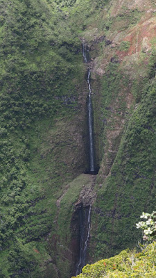 |
| Double Waterfall. Elevation ~3000' |
 |
| Ancient-style Fish Pond en route to Halawa Bay |
 |
| Sea cliffs rising into the clouds above Kalaupapa Peninsula (note island in the distance from first pic above) |
 |
| Perfect, deserted beach cove back on West End where we stayed |
 |
| And, yes, sunset from our lanai at dinner time |


1 comment:
So amazing. Such a long flight from the east coast, too!
~
Post a Comment