21 October 2017

My Scandinavian Adventure: Iceland—The Ring Road

Day 4: Dynjandi to Blonduos 493 km

Day 5: Blonduos to Lake Myvatn 239 km

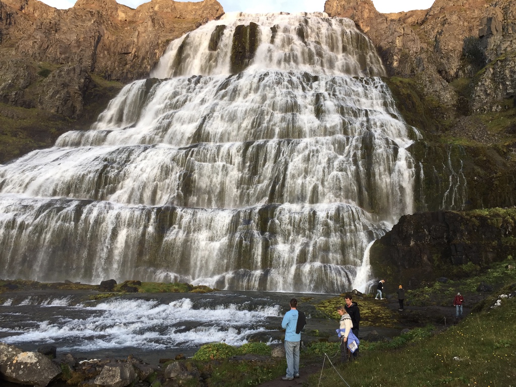
Waking up at the majestic Dynjandi Falls at the head of a lovely fjord, I didn't know which way to turn my camp chair while I enjoyed my morning tea and skyr*: towards the massive striated basaltic peaks sloping down to the glassy inlet or the multiple dramatic falls. Honestly, I kept turning back and forth. Life's choices should always be so difficult.

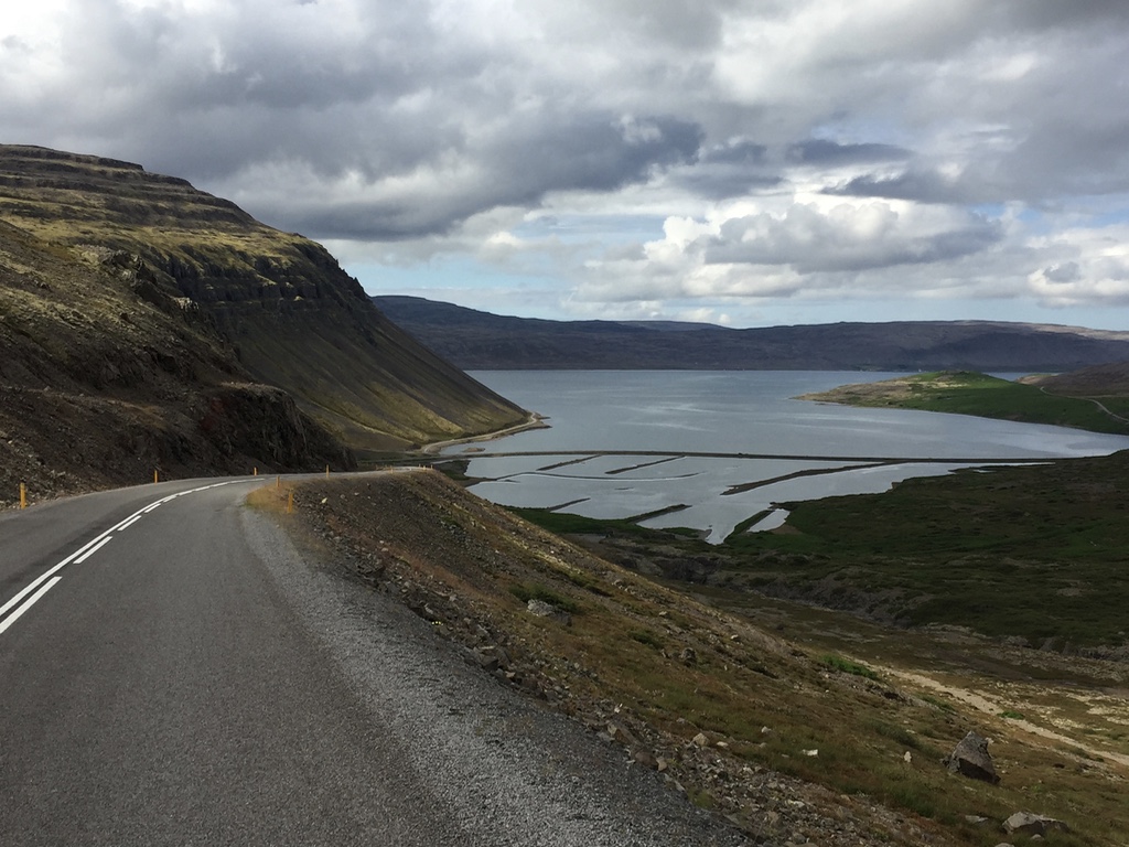
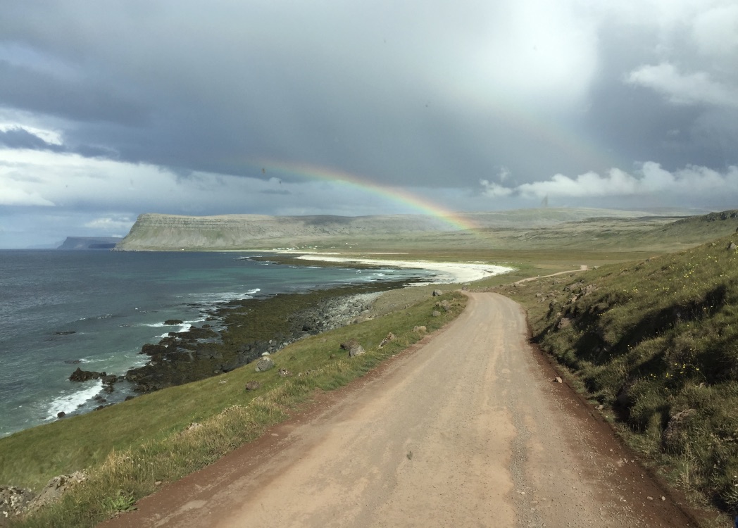
Day 4 was our longest driving day and our last on Ring Road 2. We drove some rough gravel roads along the northern edge of the Westfjords. It was in and out of the fjords all day. Fjords fjor djays. Sublime weather. I don't have a photograph, but Thingeyri was the most lovely fjord town we passed. It's worth a look-see. We had to pass up some hiking and swimming opportunities because we needed to make some time.

We hooked back up with the regular Ring Road and parked our camper van for the night at a town called Blonduos on the mouth of the Blanda River. It has a busy riverside campsite that faces north looking out over the Greenland Sea. There is nothing here between you and the North Pole. During the night we could feel the weather changing, clouds moving in from the north. It was probably the coolest, windiest night of the trip, but the great hot showers more than made up for it.

Day 5. As we got back onto the main Ring Road, we found ourselves driving in a cloud the whole day. We stopped in the quaint town of Akureyri for lunch. It is a resort town along the north shore of Iceland with charming shops and eateries. Near the modern cathedral is a sizable botanical garden that has tons of plants you don't expect to see growing in Iceland.

The highlight of the day was Godafoss. We had been debating how and why the Vikings, after raiding, pillaging, and in some instances conquering and settling much of Europe from Scandinavia to Spain to Russia to Turkey, came to such an abrupt end at the turn of the first millennium. (Every river whose name starts with the Dn sound, for example, was sailed and named by Vikings—Danube, Dnieper, etc.). Turns out it was Jesus!

The pagan Vikings inter-related with Christians and Muslims throughout their travels. But it was their kings' conversions by Christian monks which ultimately tempered their ravaging ways. Godafoss, or the Falls of the Gods, is the place where the Viking king of Iceland first converted to Christianity and flung all his pagan idols into the base of the falls.

----------
*Pay attention: Skyr is Icelandic/Viking yogurt. It is strained, so it isn't as watery as what you get here in the U.S. It has way more protein and way less sugar than other varieties. In Iceland it's all whole milk and cream. The Icelanders claim the skyr cultures are 1000 years old. It was the best food discovery in Iceland, and now it's the only yogurt I eat. Found it in my local Sprouts! (Unfortunately, it also comes in skim and only slightly less denatured milk fat varieties here.)

[Click pics to embiggen]

Random roadside hike! Taking a break to stretch our legs on a long travel day in the Westfjords.
Longing last look at the placid Westfjords with its sublime weather.
The mouth of the Blanda River at Blonduos campsite. Note the clouds moving in from the Greenland Sea.
Another Roadside Attraction: Friendly Icelandic Pony near Blonduos. They are a special, local breed and are exceptionally gentle and social.
The harbor at Akureyri.
Downtown Akureyri.
Flowers in the Botanical Gardens in Akureyri.
Godafoss: The Gods Falls.
Wesdom contemplating the demise of the Vikings at Godafoss.
Silly Icelandic Troll photobombing my pic of Godafoss.

13 October 2017

My Scandinavian Adventure: Iceland—The Ring Road

Day 3: Reykholar to Latrabjarg to Dynjandi (pt. 2) — 375km

As I mentioned in my last post, 15 August 2017 was one of the most memorable days in my life. For the record, hiking the dramatic 1500 ft. seacliffs at Latrabjarg, Iceland to view the puffins alone would have qualified it. But that was not the end. This was the day everything about the vacation changed.

Road map of Westfjords, Iceland.
You see, we are a very organized group when we travel. Our itineraries are mapped out to the minute—>"Gotta' be at such and such place at such and such time or else..." We—and when I say "we" I mean Wisdoc—had some trepidation about our—and when I say "our" I mean my—planning (or lack thereof) for the trip around the Ring Road and Ring Road 2. We had our camper van and knew the country had a terrific infrastructure for camping. So we took our maps, guidebooks, and websites (the van had its own WiFi hotspot, btw!) to plan out where we would spend each night. I figured we could improvise our way around. That way, if we found someplace we loved, we could stay longer. No deadlines. Still, Wisdoc was anxious and skeptical.

This day, after hiking to see the puffins, we wound up in a lovely little fjord town called Bildudalur around dinner time. It was ~90 km of rough road from the cliffs. The boys saw hamburgers on the menu and pounced. I said, "Guys, look where you are. You're sitting in a fishing village on a fjord in Iceland. You want to order the fish." There was some collective grumbling until we heard a booming Icelandic voice say, "Order the hamburger! It's the best in the country." The only other patron in the small cafe was a tall, gray haired man sitting in the corner. "The chef is a personal friend of mine. He knows what he's doing." Needless to say, a spirited conversation developed. Turns out the guy was a cod fisherman who was enjoying his last meal before heading out to sea at midnight. Before long, we were all gathered around his table with maps and books as he pointed out the best campsites and attractions in the country—the places the locals liked to camp when they were on holiday. Especially tonight, he said, forget your plans and stay at Dynjandi. It's not technically a campsite, but there are no rangers so you'll be fine.

The boys—who are technically men now—are, I would have to say, pretty much experts when it comes to burgers, and they swore theirs that evening were the best they'd ever had. I ate Creole style Arctic Charr, and the gals had halibut. All agreed: Vegamot Cafe in Bildudalur was the best meal of the trip, and the old cod fisherman's advice put our anxious minds to rest about our lack of pre-planning.

Dynjandi. Lordy. See the pictures and watch the short video below. The old cod fisherman said it wasn't the largest, tallest, or most powerful waterfall in the country, but it was the most beautiful. He gets no argument from me. It pours out of the highlands at the head of an isolated fjord of sublime beauty. We arrived ~9:00 pm and still had time to hike around before dark. There were maybe a half dozen others there that night, hitchhikers or bicyclists who were technically allowed to pitch tents and make use of the super clean flush toilet facilities. No hot showers there, but a historic Viking bathing pool at the foot of the falls! And yes, the air was warm enough to bathe, and the water was cold.

I mean, come on! (Click pics below to embiggen!)

The fjord town of Bildudalur in the Westfjords from the deck at Vegamot Cafe.
The view of Dynjandi Falls from the campsite parking lot. Rainbow and all. I literally leaped from the van and practically ran up the trail to the falls. The others followed.
Dynjandi 
The whole fam milling around the base of Dynjandi Falls.
Dynjandi Falls
Multiple falls. Dynjandi (There were 5 separate falls by my count)
Looking down toward the campsite by the fjord from the base of Dynjandi. See the van down there?
Hiking down to the campsite from the base of Dynjandi Falls.
The sublime colors of the fjord at twilight. Dynjandi.
Silly Icelandic troll photobombing my picture of the falls at Dynjandi. 
Approaching midnight. Campsite. Our filthy van. Fjord. Dynjandi. The end of a glorious, memorable day in Iceland's Westfjords.
Gratuitous Seacliff Puffin. Because Puffins, dammit!

04 October 2017

My Scandinavian Adventure: Iceland—The Ring Road

Day 3: Reykholar to Latrabjarg to Dynjandi (pt. 1)

There are days in your life—and you hope they are good ones—you know you will never forget even as they are happening. This one, 15 August 2017, was one for me. An all-timer. I still shudder and tear up a bit as I pore over the pictures and my notes for this blog post. And that's why it will take two posts. Please forgive.

For orientation, we woke up in a lovely town called Reykholar situated at the base of Iceland's Westfjords. We knew we were in for a longish day so we got an early start. Breakfast of Skyr (Viking yogurt, yo!), local bread, and tea in our van. We drove the fjords on the southern coast of the Westfjords peninsula, in and out of the fingers, up and down the steep mountains sweeping down to the ocean inlets. Fjords Fjor Days. Again, this is off the beaten Ring Road path and is sometimes referred to as Ring Road 2 ('RR2'). At a certain point the road forks (see below), the right turn continuing the RR2, the left, a gravel road, heading out to what's sometimes called the Westernmost point of Europe (ex the Azores): Latrabjarg aka the Puffin Cliffs. Naturally, we took the left.

We bounced and jounced along teeth-rattling, bone-jarring gravel roads for about 40km of spectacular scenery. Fjords, sea cliffs, waterfalls, villages, and magnificent beaches. Then we came to the end of the road at a lighthouse and parking lot perched atop 500+ ft. cliffs overlooking the North Atlantic Ocean. The hiking trail begins there and travels steeply uphill along the sea cliff edge for miles. Some claim it is the longest stretch of sea cliffs in the world. Some claim it is also the highest. Whatever. It is dramatic. We made sandwiches and headed out.

Oh, and did I mention that there were PUFFINS!!! We had read that the massive colony of puffins that summer on these cliffs usually leave by the 15th of August to migrate to warmer climes. We were worried because we all really wanted to see them. (Daughter-in-law Wisdil is a waterbird biologist, FYI). We got lucky. A few stragglers remained. A nice German couple I spoke with told us that the birds swarm there in mid-summer. BTW: Puffins are amazing creatures. They fly, they nest in these remote sea cliffs, they float on the ocean, and they dive to fish!

It was a nearly perfect day: roughly 60-65º F., light gusty winds, interesting clouds, sunny and bright. I'll let the pictures tell the rest of the tale. (Seriously, you'll want to click pics to embiggen them.)

The fork in the road to Latrabjarg: RR2 goes across the causeway way down there at the head of the fjord, the road to the Westernmost edge of Europe continues on around at the base of the mountain.
The gravel road to the Penguin Cliffs and a double rainbow beach. If this beach were in the tropics, it would be world famous for its beauty. Crowded. Today? Here in Iceland? Empty.
Golden Beaches. We did see local folks sunbathing in bathing suits, however.
Near the beginning of the hike along the cliffs at Latrabjarg. Note all the bird guano on the basaltic cliff face.
I've said it before here: you really want to hike with me.
How's this for drama?! People close by are kneeling to take photos of puffins. Hikers fall off these cliffs and die—it's anywhere from 1000-1500 ft. straight down. But the thing is, you can crawl right out to the edge and lie down in the soft grass and wildflowers and look over at the Puffin nesting spots.
PUFFIN PORN! (h/t Wesdom who won the family Puffin photo contest. My iPhone camera was not up to the task, even though this guy was only about 6-10 ft from us. He just stood there and posed calmly for everybody to snap his pic.)
Wesdom contemplating life.
Heading back to the parking lot which is the Western tip of Iceland. Did not want to leave this spot. The fam had to drag me off this hike. Could've stayed for hours more.
Leaving Latrabjarg, mid-afternoon, after a couple hours of breath-taking hiking and gawking. 
The fjord town of Bildudalur from the deck of Vegamot restaurant where we had the best meal of the trip. More about that tomorrow.

01 October 2017

My Scandinavian Adventure: Iceland—The Ring Road

Day 2: Arnarstapi to Reykholar - 252km


Okay, let's get oriented. If you'll notice on the map above, Reykjavik is in the SouthWest part of the island—roughly the seven o'clock position. (Click it to expand it) The main Ring Road (clockwise) pretty much goes straight north from there and then around the top of the island. At the nine o'clock position, due West, is the Snaefellsnes Peninsula. Arnarstapi is on the southern coast of this peninsula. Most travelers don't go here or the Westfjords—the jutting land mass at the ten o'clock position. It's a bit wilder, not as many inns or restaurants—though they are most assuredly there. We were not to be deterred.

There was a serene beauty about Arnarstapi that charmed my soul. It sits on a promontory of ~200ft cliffs overlooking the North Atlantic Ocean. It is isolated, yes, but people live there year round. And even though it is in the shadow of the Snaefellsjokul—the Snaefells Glacier—they get very little snow in the winter. The west coast benefits from the warming waters of the Atlantic Gulf Stream, plus Arnarstapi is in a bit of a microclimatic snow shadow nestled as it is in the crease of high mountains.

From Arnarstapi we "took the long way" around the tip of the Snaefellsnes Peninsula, traced the fjords on the north shore, rejoined the main part of the island for a few miles, then detoured up into the Westfjords. We found a great campsite in the small town of Reykholar at the base of the Westfjords. The drive was astounding though some of the roads were bumpy and gravelly. "Fjords fjor days" was my tweet. The roads wound around the edge of the mountainsides, went along the inlet fingers of sea, rounded the fjord head, then went back out along the opposite fjord edge. Magnificent. Usually in each fjord, at the head, there would be one settlement—a large farm or a small village.

The campsite in the town of Reykholar is next to the town swimming pool. It is an outdoor pool, and it has great showers. Their swim team competes with other teams around the country, and the manager of the pool can tell you where the best pools are all around the island. You need to know this if you go. Most towns in Iceland have swimming pools. Icelanders love to swim, and one of their chief forms of socializing is sitting around in 'hot pots'. Another thing to know: you can drink the water everywhere in Iceland. It is not treated with flouride or chlorine. It originates either in ancient glaciers or bubbles up through miles of lava filtration. The swimming pools mix surface water with geothermally heated water so you can swim outdoors all year long. But they make you take a shower before you enter their pools. Fair enough.

We swam in Reykholar's 25 meter pool. I did a short 300 meters. It felt amazing and so surprising! Here I was within shouting distance of the Arctic Circle swimming in a naturally heated outdoor pool! Such a feeling! Take your bathing suits when you go. Seriously. Just do it. You'll thank me. We all crammed into the hot tub next to the pool and chatted with a local couple for an hour or so after dinner. Delightful! Also to note: Everyone here speaks English. They begin learning it in like the second grade. And they are proud of their country so they love to tell you about it.

Londrangar and basaltic sea cliffs heading to the tip of Snaefellsnes Peninsula. We saw this formation from the road and had to stop. We didn't have time to hike and explore—and that was my biggest disappointment of Iceland. There is so much to do and so much to see, you simply don't have time to do all the things you want. This was a constant feeling!
For scale, there's a lighthouse in the distance and people hiking on the path up to Londrangar—another roadside attraction. I could have spent several hours here, but we had to move on.
View from pit stop for lunch, Grundarfjordur
Fishing boat, Grundarfjordur
The town of Reykholar (note the friendly ponies and marshmallow shaped hay bales)
Fishing boats, Reykholar
Geothermally heated steam rising from holes in the ground near Reykholar. Signs read "HOT! Over 130º" I wasn't so concerned until I realized that was in Celsius!
Turf roof building and Disc Golf hole in Reykholar.