 |
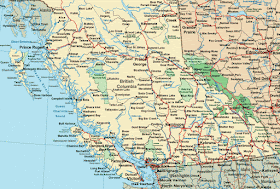
| Detail Map of Southern British Columbia and Alberta, Canada (click to enlarge and trace route below) |
If you're planning a trip, here's our agenda:
• flew to Seattle, spent a weekend with daughter and her fiancé from LA and his parents - 2182 miles;
• took a ferry to Victoria, British Columbia, spent two days exploring - ~ 3 1/2 hours;
• caught another shorter ferry ride to Vancouver, met up with son and daughter-in-law from Honolulu - ~1 1/2 hours;
• rented a camper and drove to Kelowna on Lake Okanagan - 393 km
—from there to Kinbasket Lake near Glacier National Park - 319 km
—then to Banff National Park and Lake Louise with a detour into Yoho National Park - 399 km
—then to Jasper National Park along the Icefields Parkway - 303 km
—then to Clearwater Lake near Wells Gray Provincial Park - 349 km
—then to Whistler ski resort - 530 km
—spent our last night at a campground in Squamish - 49 km
—back to Vancouver - 33 km
• dropped son and d-i-l at Vancouver airport, returned camper, and caught Amtrak from Vancouver back to Seattle - ~4 hours.
• flew next day back to ATL.
By my inexact calculations,
—I drove the RV a total of 2450 km, or 1522 miles
—hiked ~52 miles with a total of ~3500-4000 feet of elevation change
—city walked (Seattle, Victoria, Vancouver) ~25 miles
—biked ~13 miles (Victoria).
 |
| Plane ATL to SEATAC |
 |
| Ferry Seattle, WA to Victoria, BC |
 |
| U-bike rental, Victoria, BC |
 |
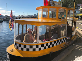
| Adorable water taxi, Victoria Harbour |
 |
| Ferry Victoria to Vancouver |
 |
| RV Camper |
 |
| Merrell Hiking Boots |
No comments:
Post a Comment